![]()
Premier Energy’s utility drawings service provides the best level of design information available.
Utility Map Drawings
AN OVERVIEW OF OUR SERVICE DRAWINGS
We have developed our utility map drawings over decades. Whilst there will always be changes we do endeavour to plan the utilities according to NJUG requirements and coordinate with other consultants’ information such as drainage and landscape requirements.
To complement our New Connection and Diversion services we provide a range of utility drawings to meet your needs.
What are Utility Drawings?
Utility drawings are detailed diagrams that specify the type, location, and depth of various services such as water, gas, and electricity lines. They play a crucial role in minimising the risk of service strikes during excavation construction projects and enhancing understanding of existing infrastructure before any digging commences. These drawings are indispensable for ensuring safety and efficiency in construction and maintenance endeavours.
The Benefits of Utility Map Drawings
Utility map drawings are essential tools in construction and infrastructure development, providing crucial information about underground utilities. They offer several practical benefits that improve project safety, efficiency, and cost-effectiveness. By accurately mapping underground infrastructure, these drawings help prevent damage during excavation, ensure regulatory compliance, and support efficient project planning.
- Accurate Representation
- Safety
- Efficiency
- Cost Savings
- Regulatory Compliance
- Environmental Protection
- Planning and Design
Who Are Our Clients?
We specialise in utility map drawings for clients across multiple sectors. With decades of experience, we adhere to NJUG standards and coordinate seamlessly with other consultants. Our portfolio of case studies highlights our capacity to provide efficient utility drawings that optimise infrastructure planning, minimise project delays, and enhance overall project safety and reliability.
- Architects and Engineers
- Environmental Consultants
- Local Government
- Architects, Planners, Lawyers and Surveyors
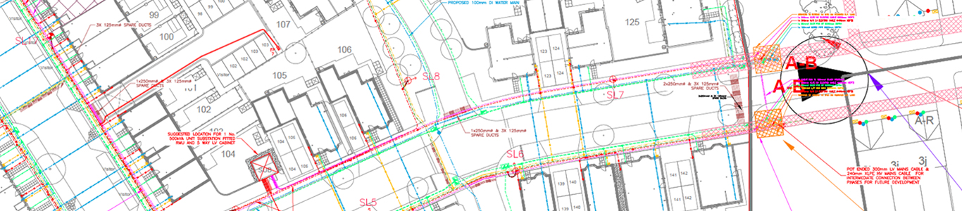
EXISTING SERVICES DRAWING (ESD)
- Taking either the DWG information from our PALM drawing product or drawing the utilities directly on a topographical drawing
- Using features on the topo we create a utility map drawing that reflects the asset maps as closely as possible without actually doing a CAT scan/GPR survey
- If asset maps of private plants are available we can also add these to the ESD
COMBINED SERVICES DRAWING (CSD)
- Provide a service strip, road crossing ducts or even a pre-quotation utility design proposal at an early stage to assist with the groundworks tender package
- The CSD shows the proposed diversions, points of connection, routes of mains, service connections into properties (including types of metering), road crossing ducts and ducts into buildings
- Routes of mains and services are coordinated with drainage proposals to avoid any clashes with other constraints such as tree roots
- We can add street lighting connectivity to the CSD based on designs provided by others
INTERNAL SERVICES DRAWINGS (ISD)
- Where an M&E consultant is not appointed due to the low complexity of a block of flats, we can provide a route planning service
- Your M&E contractor should have sufficient information to offer a design and build service from the information provided
- Our drawings show routes of services through communal area floor plans, elevations and sections, plus duct entry into buildings